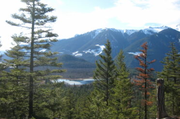
It was a beautiful sunny day in October and we were in Tyax camp, located a two day ride from civilization. The snow around the camp was still thick when we went to bring the horses in from the staking meadow after breakfast. We were on a wild sheep tracking trip. The guests, Kevan and I saddled the horses and got going. We were planning to ride around Relay Mountain to look for the sheep herds. Halfway there, Kevan thought we better also cover Castle Peak. From former studies we knew that the mountain goats like this habitat and get their minerals from the peak.
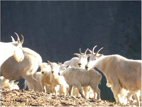
I got very excited as I always wanted to discover Castle Peak which is a geologically interesting formation and the mountain goats are one of my favourite species. The goats are one of the most impressive species with their long white winter coat and well adapted to their habitat. Their disproportionate huge, muscular forequarters and specialized hoofs support them climbing steep and rocky slopes or on snow and ice (Ministry of Environment, Land and Parks, 2000), their evolution is a relic of the ice age. The mountain goats tend to migrate vertically and not much horizontally. Their habitat is the alpine terrain, when they need shelter or shade they migrate to lower elevations around the treeline. This means that the species already lives in the highest possible altitude, which makes me concerned about their ability to adapt in times of climate change. When I had the opportunity to conduct a mountain goat population survey last year, I became very interested in studying this species. In British Columbia we are especially responsible to protect and manage their habitats as over 50% of the world’s individuals reside here (Ministry of Environment, Land and Parks, 2000).
The mountain goat is on the blue B.C. List, which means that it is a species of special concern and is “sensitive or vulnerable to human activities or natural events” (BC Species and Ecosystem Explorer, Ministry of Environment, 2019). The Wilderness Stewardship Foundation (WSF) collected data (population monitoring, DNA collection, data acquisition) of the herds habituating in the Bridge River Watershed over the last 28 years to contribute to the improvement of the status (Wilderness Stewardship Foundation website, 2020). WSF`s conservation aim is to increase wildlife populations to the carrying capacities of the ecosystems.
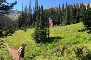
Once we dropped down in the meadows and bushwhacked for a bit through thick firs we came to the open sandy shale slope that our horses climbed up easily. When we arrived at the top we traversed towards Castle Peak, which you can see in the picture. The peak is an important orientation mark in the area, because of its remarkable shape. The ascent towards Castle Peak is too steep and rocky, so we dropped back down on the southern slope to get back high on a less steep spot. Climbing up the sandy shale with a few rocky parts in between, was not as easy as i thought. We had to get to the north-west side of the peak to get all the way up, the eastern and southern slopes were too steep. To get there we had to ride right below the peak, at this point a couple of rocks fell down and missed Kevan by a few metres. By the time the rest of us crossed, luckily no more rocks fell down, but my heart rate went up anyways. Finally arriving up at the foot of Castle Peak I could not wait to get up on the rocky parts to discover the peak and traces of the goats.
The lava rock here is a result of a volcanic eruption. Lava, heated up to very high temperatures, erupts from inside the earth in a fluid form and flows out of the crater. Within the lava, gas is encaved. Due to the high difference of temperature between the inside of the volcano and on the earth’s surface, the liquid cools down and becomes hard rock so that the bubbles become little holes in the rock that can still be seen.
The structure of Castle Peak is layered. Layers of solid lava rock are alternated with fragile mineral-rich material. The mineral rocks are colourful. White comes from magnesium or calcium, yellow for sulphur and red for oxygenated iron. We found multiple little caves within the mineral-rich material in the peak formation of Castle mountain. These are between 3 and 15 ft deep carved into the rock and have a height of 4 ft. Guess where they come from! The mountain goats licked and carved the material off with their teeth to get those minerals. In some of the rocks, you can even see the tooth marks. Imagine since when the goats must have been carving out these holes that they could get up to this size, probably more than a thousand years. Discovering the place where a species resides for such a long time and is actively shaping a landscape made me once again realize the eternity of nature in comparison to our short lives on earth.
Lisa, Germany