Eldorado Camp
Summary: Eldorado is perfect for intermediate hikers and riders. This area is rich in history and inhabited by mountain goats, mule deer and grizzly bears. This story will give you an introduction to the Eldorado of the South Chilcotin Mountains.
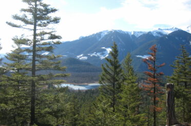
When you see the word Eldorado, does it conjure up images of South American kings and empires of gold? Well, to us, Eldorado, one of our twenty-five wilderness camps, is a mountain full of treasures and not just gold. There are grizzly bears, mountain goats and mule deer, 150 different species of wildflower, the purest water you’ve ever tasted and red sandy shale mountains to name but a few. You can access our Eldorado via the trailhead at the Taylor Mining Road, from Cinnebar or you can start at our ranch and travel up the old B&F Mining Trail and into the Eldorado Basin. Whichever way you take, you’ll be captivated by sights as enchanting as the names of the trails. Your breath will be taken away by spectacular views, roaming wildlife and blooming wildflower meadows. You will feel the energy on every ridge and in every valley. Want to hear more about the place that we call Eldorado? Read on.
This trip to Eldorado
will be a little different for me. Instead of riding, we’ll be
hiking, meaning we will have to get to the mountaintops under our own
power. Windy is our pack horse, carrying all our supplies so that we
only have our day packs on our backs. Our guests are husband and
wife, Stu and Rita, long time hiking companions, ready for their next
wilderness experience. They’ve hiked all over the world but the South
Chilcotin Mountains keeps calling them back, they say the energy of
this place is different, welcoming, peaceful, addictive.
Dale and I are the
mentor guides. We teach Rita and Stu how to pack Windy and they
quickly learn the knots. We hit the trail, ready for a new challenge.
This is a four-day trip and we’re determined to pack as much in as we
can. We soon find that hiking leaves us more freedom to walk side by
side when the trail is wide enough instead of following in a line
like the horses do. We all alternate leading Windy who follows like a
lamb.
The B&F Trail was
created over 100 years ago when miners packed their supplies in and
their gold out on horses. We are walking a piece of history. It is
named after the two miners that created it, Bunton and Ferguson. From
the B&F Trail, we emerge into the lunch meadow. Windy makes the
most of his meal of blue lupines, yellow balsamroot and red Indian
paintbrush. We look back at the view of Carpenter Lake and the Bendor
Range to the south of us. Mount Truax with its distinctive jagged
peak will help us navigate throughout the trip. We see two mule deer
does some grazing across the valley in their own meadow. Rita and Stu
already have an introduction to nature connection, South Chilcotin
Mountains style. They’re eagerly anticipating more.
After lunch we begin
our descent, checking to our left for the radio tower, a distinctive
landmark we use for navigating. We can see Castle Peak, just a tiny
point between two other mountains ahead of us. We’ll see it much
closer tomorrow, showing Stu and Rita the mountain now creates
another feeling of excitement and will help them piece the mountains
together as they see familiar places again and again. We point out
the radio tower to Stu and Rita so they can check for it themselves
as we hike into camp. In front of us is a white rock on the side of a
red sandy slope. Our Eldorado Camp is in the valley below those white
rocks. It seems impossibly far away but we remind Rita and Stu they
are already halfway. This was a great way for Rita and Stu to put
things in perspective. Now they were re-energized, “Look how far we
walked,” Rita says, “We’re fast!”
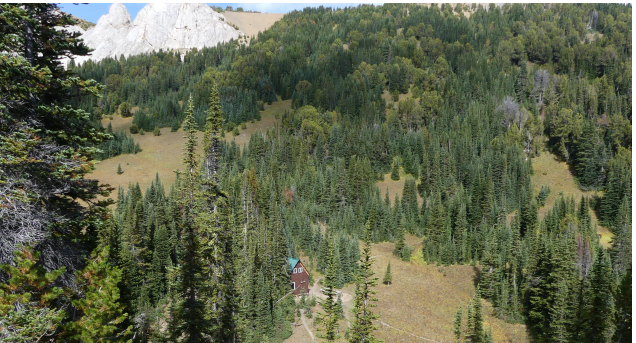
We are soon down in
the Eldorado Basin, walking through grassy meadows, past small ponds
and back into forest. The last stretch is slightly uphill again
before we come to open meadows that extend up the mountain slopes. We
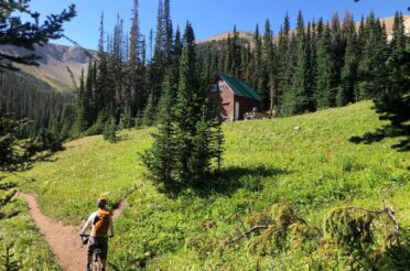
turn left and into the valley where our cabin is hidden. After seven
hours of hiking, we are all appreciative to see the cabin appear
through the trees. We walk Windy up to the door and take his pack
boxes off. Before we can make dinner, we have one last hike to the
grazing meadows to stake Windy for the night. After packing in all
our gear, we know he’s fully earned his dinner. Rita finds the best
patch of grass in the meadow and we set up our stake. We teach Rita
and Stu how to hammer in the stake using the flat end of a splitting
maul (we use the sharp end to split firewood) and tie the bowline and
daisy chain knots to secure Windy to the post.
Once we’ve taken care
of Windy for the night, we make our own dinner and pack in the water.
The tiny creek that runs just down the hill from camp is the freshest
glacier water Rita and Stu have ever tasted. For Dale and I, it is
one of the best water sources we know. Rita and Stu are experienced
fire makers and relish the opportunity to get our campfire going. We
soon have the perfect fire to cook our dinner on. We make sweet and
sour chicken with rice. Everything is cooked perfectly and we eat
around the fire pit, telling stories about our day, reflecting on the
successes and struggles. Before we head to our canvas wall tents for
bed, we all decide we’ll make the real last hike of the night. Windy
is staked close to camp, something that is particularly important
because he’s a lone horse, and we check he’s okay before we go to
bed. He’s grazing contentedly, his bell ringing gently so from our
tents we’ll know he’s there. We collapse into the cots in our tents,
appreciative to take the weight off our feet.
The next morning
we’re up early. We’re going to hike the west ridge of Eldorado, a
circle of mountains around the camp. It’s a much shorter hike than
yesterday but we want to scout for mountain goats at the top so we
take plenty of time for this. We unstake Windy and bring him back to
camp before breakfast. Again we cook on the campfire: bacon, French
toast and fried potatoes. We enjoy the meal so much we don’t get up
to move until Windy starts pawing the ground impatiently. “Time to
go!” he says.
If we have two pack
horses or a real experienced old-timer, we might leave them at camp.
Windy is a younger horse so we bring him with us to give him some
company and make sure he stays safe. We wind our way up to the
ridges. As we get closer to the treeline, the only trees are white
bark pine. This is a perfect opportunity for us to educate Rita and
Stu on the importance of the white bark pine tree. As we climb
higher, these brave, hardy trees get smaller and smaller. They are
easily identified by their white-grey bark and the fact that their
needles grow in groups of five. Every three years they produce their
pine cones and then the squirrels, Clark’s nutcrackers and grizzly
bears of the area feast on the nutritious pine nuts. These three
species are important for the white bark pine as they disperse the
pine nuts facilitating their growth cycle. The nuts are important for
the animals as they provide a vital source of protein. For grizzly
bears, the amount of protein in the nuts means it isn’t unusual for
the bears to have three or four cubs when the average everywhere
outside the South Chilcotin Mountains is one or two. White bark pines
grow in distinctive clumps, when we see these we know this was once a
forgotten squirrel cache of white bark pine nuts.
As we walk higher, we
emerge above the trees and show Rita and Stu the first lookout. From
here we can see the radio tower looking impossibly small in the
distance. And on the horizon is Mount Truax, now a hazy blue. We know
which way the ranch is. We continue onwards, the next mountain top is
higher and now we’re above even the white bark pine. Around the
corner, we spot Mount Sheba, identified by its twin peaks. This is
the tallest mountain in the South Chilcotin Mountains Provincial Park
and it’s highly distinctive so we use it for navigation. We continue
on, following the ridgeline because the sandy mountainside means the
trail is all but blown away. At lunchtime, we make it to the tallest
mountain for the day, Spruce Peak. As we sit down to eat, Dale and I
point out the mountains that surround us. Mount Sheba is still just
visible to our west. Now we can see Castle Peak again. It is still a
hazy purple colour but we can see a lot more of it than yesterday.
There is Cardtable Mountain to the right of Castle Peak, identified
by its flat rocky top. Fortress Ridge, Mount Relay and Nea Peak are
more that we can point out to Rita and Stu. At the top of the
mountain is the perfect time to reflect on our day so far. We all
reflect on the difference in experience between hiking and riding up.
We have reached the mountain top with the power of our own legs. It’s
an incredibly empowering experience and makes us appreciate the views
even more. Once we’ve eaten we take out our binoculars and scan the
mountainsides for goats. Then, just below us, we spot five goats. We
inch closer to the edge and more goats appear. Seven, twelve,
nineteen… there are twenty-five goats in total – nannies, kids and
yearlings! We inch closer, watch through our binoculars, not daring
to breathe in case we spook the goats away.
The goats look up at
us. We’re so close we can read the expressions on their faces. They
aren’t worried by us, they’re used to hikers and riders. In their own
time, they amble away, picking their way over the rocks to the next
patch of grass. Lunch finished, we get up and carry on. The descent
from Spruce Peak is easy in the sandy shale. We zig-zag down and
because we still have some time, decide we’ll walk over to Windy
Pass. This is the way to our Spruce Lake Camp. Many of our horses are
named after mountains, lakes or passes in the area. This is Windy’s
place. And it lives up to its name. As we get to the pass, the wind
howls around us, until now the wind has been almost non-existent.
With the afternoon
wearing on, it’s time to get back to camp. We bring Windy all the way
with us so he can eat his oats before we stake him in the meadow.
Tonight’s dinner is ham and rice again cooked on the campfire. Once
more, we share our stories around the campfire, reflecting on the
challenge of the hike, the nature connection of seeing the goats and
mountains and the sense of peace quiet places bring.
The next morning we
are up early. We’re hiking back to the ranch, but we want to show Stu
and Rita the Taylor Mining Cabin first. Eldorado is a special camp
for many reasons but one of them is that it’s a camp that can be
accessed from multiple routes which I explained at the start of this
story. The route we are hiking out is via Eldorado and Camel Passes,
onto the High Trail and Cinnebar Mining Road. We have Windy packed up
early and, fortified by a breakfast of sausages, scrambled eggs and
toast, we hit the trail. At first, we walk back towards Windy Pass.
Stu and Rita recognize the way, they have been paying attention. We
turn right instead of left and soon our trail becomes the Taylor
Creek Trail. The trail turns from lush grazing meadows to small shale
rocks and then larger red rocks. We are in mining country now. The
Taylor Mining Cabin is only a slight detour from the Pearson Trail
that will take us over Camel Pass.
On we hike and soon
we see the creek where the cabin is. Set back a little from the
trail, the old cabin has a sunken feel to it. It is low in the
ground, the door is only five foot high and sticks as we try to open
it. The cabin is small and dark but with a flashlight, we can take a
look inside: beds suspended from the ceiling, the names of countless
visitors scrawled across the walls. It sure feels like we’ve stepped
back in history. There’s an old-style outhouse here too. It has no
door and no seat, only a log above some exposed soil. There’s a
shovel outside.
Because we’ve got a
tight deadline, we don’t spend long at the cabin and begin the hike
back to Eldorado Pass. Here we turn left onto the Pearson Trail. We
are traversing a rocky mountainside, looking far into the Taylor
Basin where a small creek runs and the grass and trees grow brilliant
green. Eldorado is right on the edge of the Park which means as we
hike the Pearson Trail we re-enter the Park which we left when we
turned onto the Taylor Creek Trail. Mining isn’t allowed in Parks,
meaning this area isn’t protected. It sure provides for a striking
change in landscape. We reach Camel Pass and are buffeted by the wind
again. It is a thin, grey rock ridge. We begin our descent knowing
it’s all downhill to the ranch. We’re now on the Camel Pass Trail and
when we reach meadows again, we rejoin the High Trail. This is the
perfect place to stop for lunch at a campsite. On we hike and soon we
have reached the Cinnebar Mining Road. This road is longer than you’d
think. When you think you’ve reached the end, you’ve only gone
halfway. Windy’s hoofs kicked up dust. We stop a couple of times for
Stu and Rita to take pictures of the tiger-lilies and red columbine
that grow beside the trail.
At the end of the
Mining Road, we weave our way along the trails behind the ranch to
arrive home much quicker than if we walked the main road. This has
been a truly inspirational hike for Rita and Stu. They are already
thinking about taking another trip in the South Chilcotins. They want
more time in the wilderness. They say there is a unique, peaceful
energy about this place. Dale and I agree, we feel it all the time.
Charlie